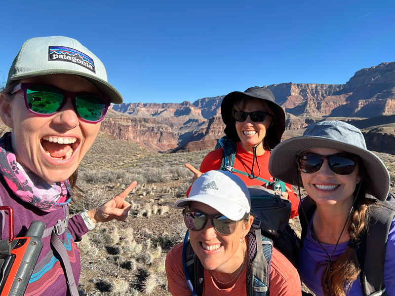
Grandview Horseshoe Mesa Loop
TRAIL STATS
The Grandview Trail takes you down to Horseshoe Mesa where you will enjoy sweeping views of the Grand Canyon and mining relics from days long past. Dropping almost 2500 feet in just over 2 miles, it’s not a trail for the faint of heart and will require a steep, heart-pounding climb to get back out. From here, you can stay and explore the top of Horseshoe Mesa or drop another 1200 feet onto the Tonto Bench to make a 7-mile loop around it, getting even deeper into the canyon and even enjoying a tiny glimpse of the Colorado River. To spread this trip out into more days, you can backpack this route and camp at the campground on the mesa or in the areas below the mesa (permit required).
Trail Description
By any other standard, this is a 5-star hike, but this is the Grand Canyon. Every single hike we have ever done here is simply spectacular, and compared to some of our other favorites, it only gets four stars. By no means does that mean its not worthy of your time. Not only does this trail get you away from the crowds on South Kaibab and Bright Angel, but it also provides a peek into the history of the area. I just wish it had more river views!
Grandview Trail was originally used by Native Americans and later enhanced by miners in the late 1800s to access the riches of the Last Chance Mine, which you will pass on the loop. Since the route is so steep, some parts of the trail were paved with stones so that mules could get good footing while hauling ore up from the mine. Due to the mining history here, you will see an old mining camp building, some mining equipment, and the opening to Last Chance Mine (gated) on this route. Sounds like there are other mines in the area, but we only saw this one mine on the loop. Since uranium was one of the minerals that came from this mine, there are some radioactive zones with signs posted to keep hikers out.
Water Before you head out, you can usually get water from the nearby South Kaibab Trailhead, but you should check with the Park Service website to make sure it’s turned on before relying on it. There is no water on the Grandview Trail or Horseshoe Mesa, but you may find water at springs below the mesa. According to the Park Service, only Hance Creek is a permanent year-round water source, while Cottonwood Creek occasionally runs dry in hot weather. The other springs are unreliable. We found water at both Cottonwood Creek and Hance Creek when we went in December. Check with rangers for current conditions, and plan to carry around 4 liters each to get through this hike. Bringing a water filter would be prudent, just in case. Remember, this is a desert hike with little shade that requires a lot of physical exertion. Be smart!
Grandview Trail
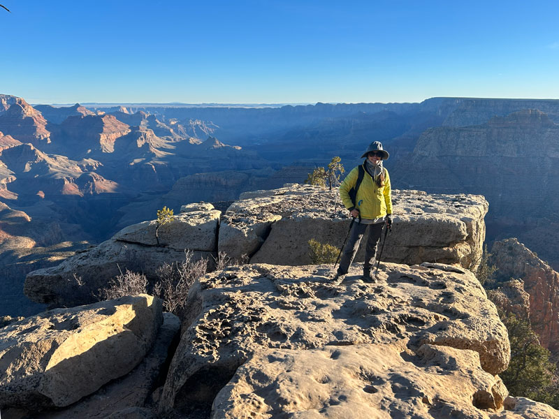
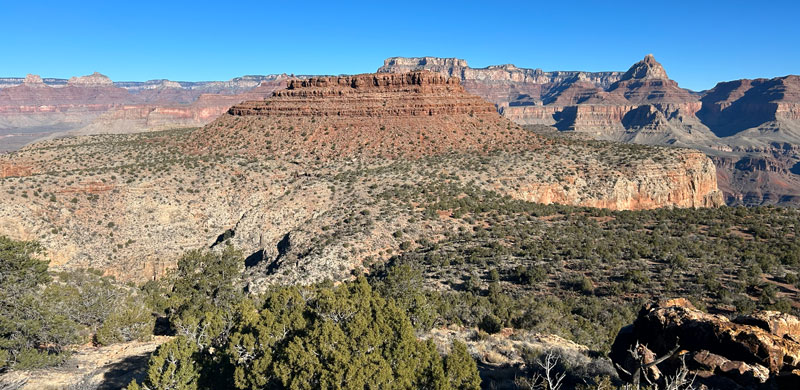
From the Grandview Viewpoint, head past the signs to start down the trail. That first view of the canyon always makes my heart flutter, and I don’t think I’ll ever get used to it. Some of the best, most expansive views are from the upper reaches of this trail, so be sure to spend a little time taking it all in!
If you’re hiking it close to the shortest day of the year like we were, you might be hiking out in the dark, which means no more views. Even if you don’t think you’ll be hiking out in the dark (us), assume you’ll be hiking out in the dark (also us). Did I mention to bring a headlamp? Because if everyone in your group forgot one, I hope you stopped by the Safeway in Williams to pick up a cheap one. Yeeeaaaahhh. That’s embarrassing.
During the winter months, ice and snow can accumulate on this trail. It had been several weeks of warmish weather since last snow when we went, and there was still some on the trail in the shady spots. It wasn’t enough to pose a hazard for us, but it CAN become a problem. Again, ask rangers for current conditions. You may need additional traction.
Well, if you haven’t clicked this webpage closed yet, and you’re still determined to go, we’re kindred spirits and you’re going to love this adventure! So get going on those switchbacks!
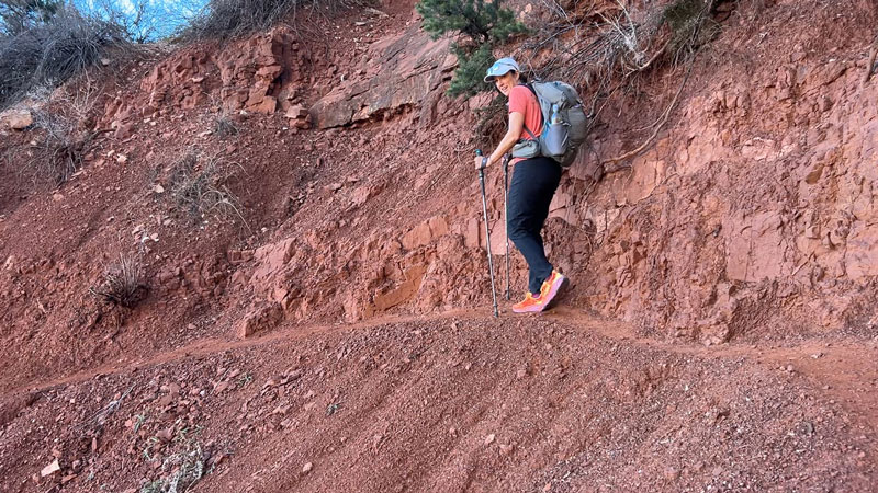
This trail may not be as well-groomed as the Bright Angel Trail, but by most standards it’s pretty darn nice. As the trail descends through the Kaibab and Toroweap formations, it has a lot of steps built in, supported by logs.
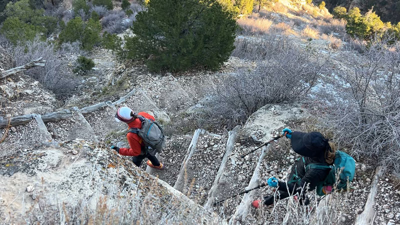
There are moments along this trail where you’ll want to pay careful attention to footing because a slip and fall could have catastrophic consequences. Hiking poles are highly recommended (as in, don’t leave home without them).
Coconino Saddle
Just over a mile in, after dropping more than 1000 feet in elevation, you’ll arrive at a large saddle that has views off either side of it. This is a great spot to sit and take a rest because it has plenty of space and some trees for shade. Apparently I was too preoccupied with resting to snap any photos.
The trail in this area is paved with stones much of the way, especially on the steeper parts. Switchback after switchback, you’ll probably think how much this will suck on the way out, and it will, but at least it won’t be too slippery.
As you approach the mesa, the trail becomes less steep and has a few washed out parts with some boulders you will need to negotiate. The scattered boulders can make it harder to keep track of the trail, but the key is always to cross the washout, not go down it. The trail will resume on the other side.
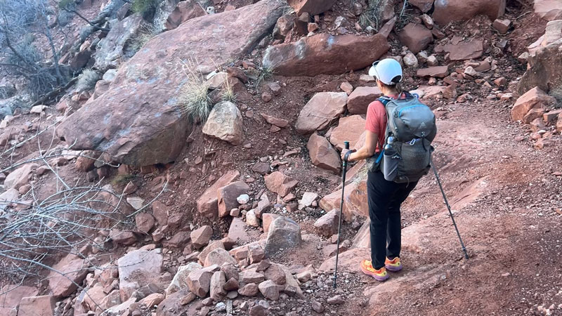
There’s also one spot where the washout has left nothing but a narrow path only a few inches wide. It feels a little less fancy than the paved stone path, but at least the views out into the canyon are phenomenal through here.
The track we had showed the junction for the loop in the wrong place. That led to some confusion about which trail we were on, and on the way back, it took us right through the radioactive zone. No bueno. Have patience, and wait until you see the big, obvious sign pointing left for Cottonwood Creek and right for Hance Creek. Horseshoe Mesa is straight ahead.
Horseshoe Mesa
You can hike this loop in either direction, but we chose to hike in a clockwise direction – toward Cottonwood Creek first, across on Tonto Trail, and up near Hance Creek. We heard the trail coming up from Hance Creek was more steep and rugged, which turned out to be true, so we were glad we were hiking up it, not down.
Somewhere near here is a good place to cache water for the hike out. We each cached one liter. Do not leave any food, though, unless you have a rat sack to protect it. The critters around here are pretty curious and good at getting into things.
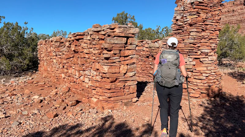
If you continue past the junction for Hance Creek, you’ll arrive at Horseshoe Mesa. The trail toward Cottonwood Creek will break off to the left, but if you continue straight ahead, you will see an old masonry building on your left that has some artifacts and a fireplace inside. Note that the structure and any archaeological artifacts (cans, nails, etc.) are protected by law, so please enjoy but don’t disturb!
Signs for the toilet and the campground point you to your right. If you need to go number 2, there’s no better time than now.
Horseshoe Mesa Campground
There are three small campsites near the toilet. There is NO WATER available at this campground, so be sure you have what you need for the night if you’re staying here. We looked at one of the sites, and it was basically a big, flat area with a few shrubby trees. The group campsite is farther north.
From here, a trail leads out to each of the arms of the horseshoe-shaped mesa, and rumor has it that they make a phenomenal place to watch the sunset or sunrise. We were looping around the mesa, so we did not have time to hike out to these viewpoints.
Cottonwood Creek Trail
Just before the masonry structure, you’ll find the junction with the trail that heads down to Cottonwood Creek. This trail doesn’t waste any time getting down to business. Before you know it, you’ll be descending quickly down switchbacks with loose rocks as your footing. You brought those poles, right?
After a mile, the trail flattens a bit and you’ll arrive at Cottonwood Creek. There was water in it when we went, but apparently it does run dry in hot weather. Near the creek are a couple of nice camping spots, which I marked on the map. The camping here is “at large,” meaning there are no designated campsites. However, you will still need a permit from the Park Service.
Tonto Trail
The trail more or less follows the path of Cottonwood Creek for the next half mile before reaching the junction with the Tonto Trail. Look for the trail to continue along the shelf to the right.
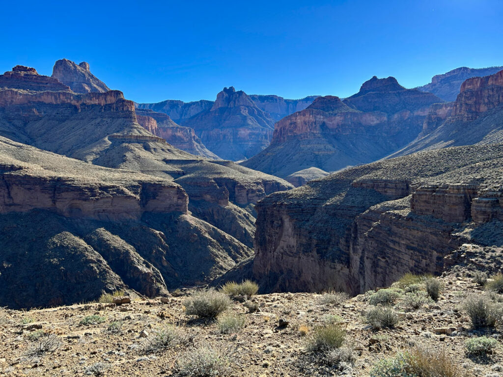
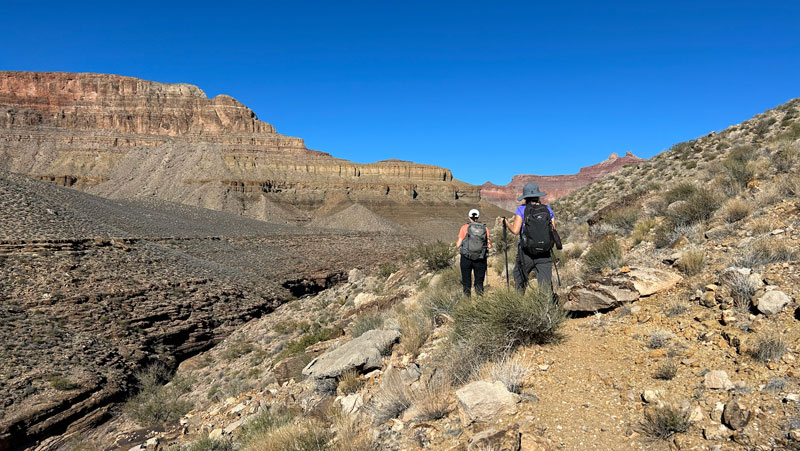
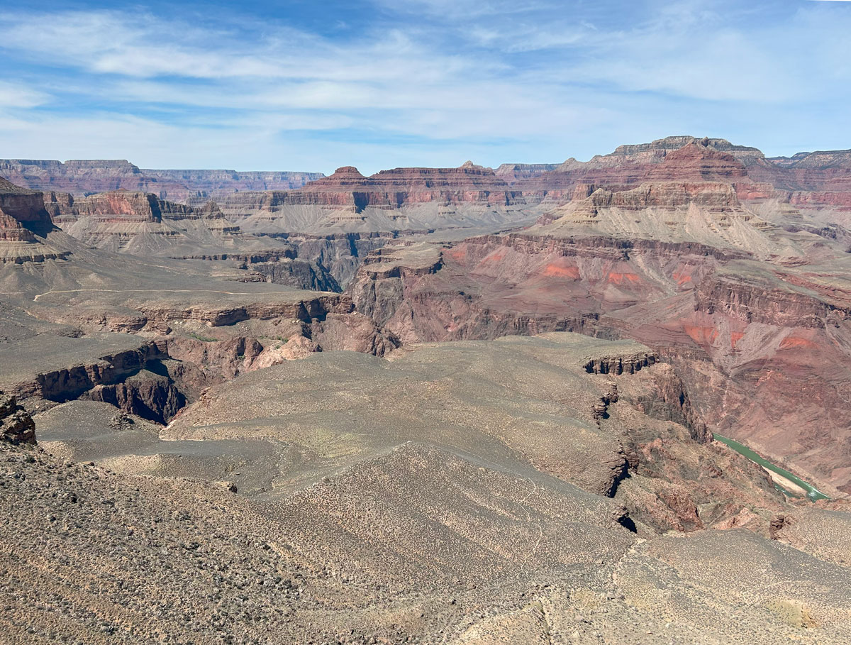
The next four miles on the Tonto Trail have less elevation change as you head up canyon on the Tonto Bench—a wide, relatively flat shelf. This section is dry, dusty, and offers very little shade. Any misstep could land you in a cactus, forcing you to lose precious time plucking spines out of your booty (as we found out the hard way).
The main attraction here is the views.
Shortcut Back to Horseshoe Mesa (optional)
If you can imagine the route as a heart-shaped lollipop (look at the map to see what I mean), when you get to the middle of the top of the heart, you’ll see a signed junction for a trail that heads back up onto Horseshoe Mesa. This is your bail point if things aren’t going as planned or you just want to shorten the hike. We did not take this trail, but the Park Service describes it as “the most civilized” of the three trails that connect Horseshoe Mesa with the Tonto Trail. Sounds downright luxurious!
Hopefully you don’t have to take this route, though, because the best is yet to come!
Continuing on Tonto Trail
Surprisingly, it was very hard to get any view of the Colorado River from the Tonto Trail. We did not even catch a glimpse of it until we were on the far side of the right lobe of the “heart.” Even there, it was small and distant. But we were still excited to see it!
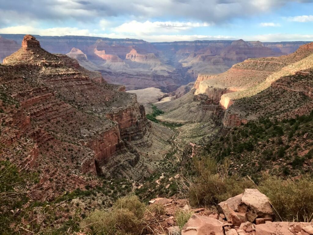
What we lacked in river views, we made up for with canyon views as we headed up through Hance Canyon toward Horseshoe Mesa. Picture of the day coming up!
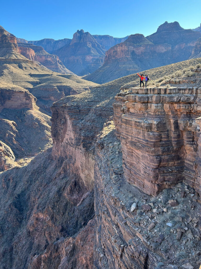
I marked one of the sweet viewpoints on the map, but there are honestly so many. This was the most stunning section of the hike, so make time for it!
Unfortunately, these views do have a price. The trail you are about to take back up to Horseshoe Mesa is a doozy that the Park Service describes it as “the most difficult and exposed.” Remember what I was saying about hiking clockwise around the loop? We wanted to be hiking up the most difficult sections, not down.
Perhaps the most confusing section of this trail is right where the trail enters the wash for Hance Creek. It’s here you need to get off the Tonto Trail and onto the trail that goes up to the mesa. While your group’s navigator takes a look at the map, be sure to look down in the wash for some brilliant blue rocks.
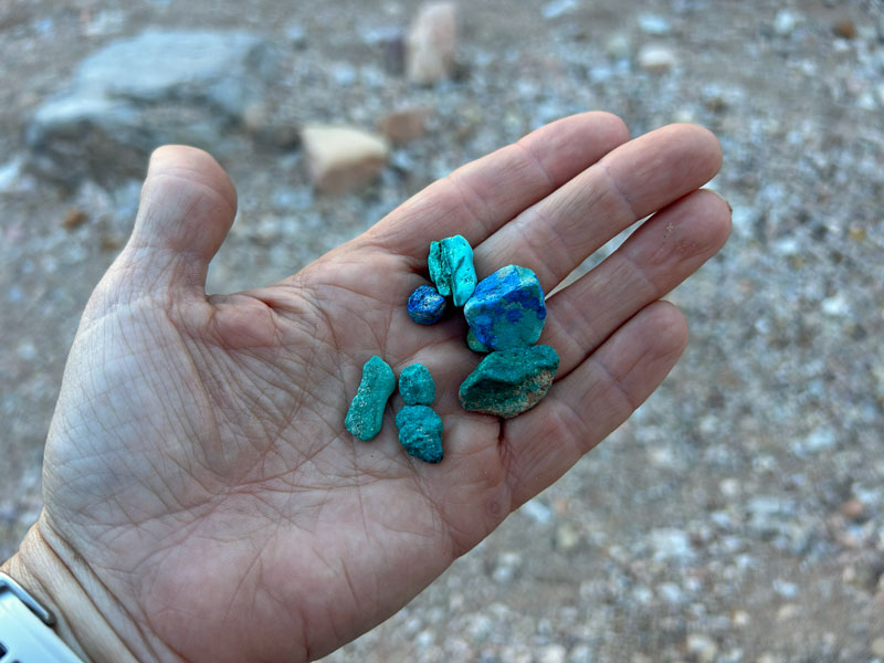
We learned that these are copper-based minerals that are commonly found near copper mines like the Last Chance Mine you’ll be passing soon. One source said the green ones are malachite and the blue ones azurite. The colors of these stones pop against the desert backdrop, making them fun to look at.
Please note that collecting these rocks in Grand Canyon National Park is prohibited. (Besides, you’re about to make a beast of a climb out of this place, and you don’t need any extra weight.)
Hance Creek Trail
Our tendency at this point was to hike up the wash, but we soon realized we needed to get up onto the left bank to get on the actual trail. Here, the trail generally follows the course of Hance Creek, which was a wash in some areas, but a running creek in others.
If you’re dreading the climb out at this point, you should be. As we started up, we were huffing and puffing, thinking we had made all kinds of progress. When we checked the map, though, we had barely inched up the elevation profile. It was gonna be a long journey.
Ahead, an imposing wall of rock looms over you. This is the Grand Canyon’s magnificent Redwall layer. Yep, somehow you’re getting up there!
Page (aka Miners) Spring
As you get rather close to that wall of rock, look for a sign marking the junction for Page (Miners) Spring off to the left. We did not have time or desire to go to it, but the Park Service calls it unreliable. Check with a ranger if you are hoping to use it.
The next part of the trail is surely the part that gave this trail its reputation for being “difficult and exposed.” You’ll be making big steps up loose, rocky, unmaintained switchbacks. Say, you do have those poles, right? For stability? (Okay, okay, I won’t mention it again.)
Last Chance Mine
Near the top of this layer, you’ll come to some old mining equipment and the entrance to the Last Chance Mine!
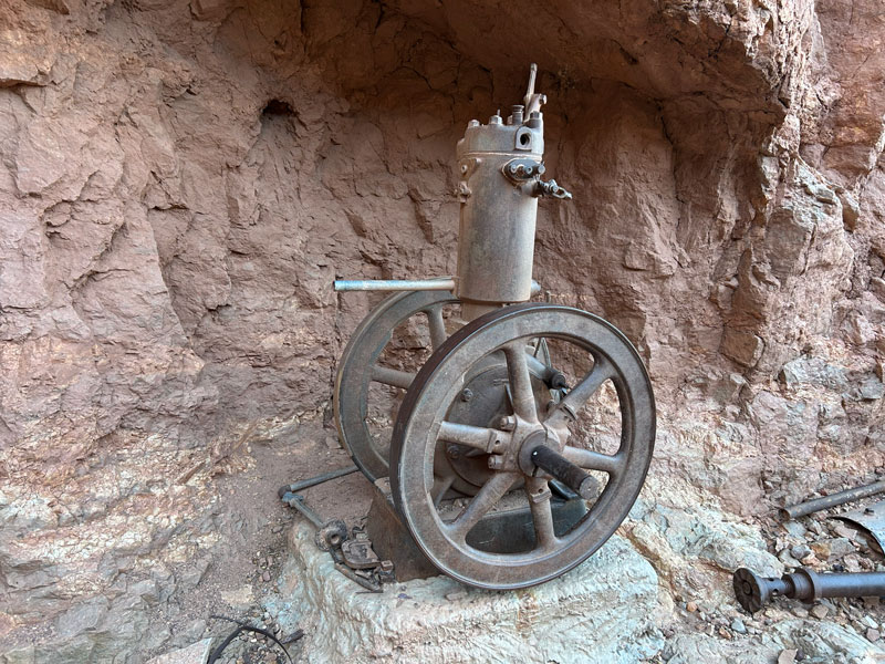
Entrance into this mine is dangerous and prohibited. Also, there’s a gate to prevent access in case you get any dumb ideas.
From here, it’s not too long before you’ll find yourself back atop Horseshoe Mesa. A few more mining relics can be seen up here next to the trail.
Carefully placed stones guide you along the proper route back to Grandview Trail, but the track we had shortcut this trail and took us right through the radioactive zone. Have patience and follow the trail back around to the junction to avoid eroding the area further (and radiation exposure, obviously!).
The Hike Out
We arrived back on Horseshoe Mesa right before sunset, and while we did enjoy watching the setting sun casting a warm glow on the distant cliffs, we knew we didn’t have any time to spare. We grabbed our water cache, ate a quick snack, and got back onto the Grandview Trail for the strenuous hike out. It was obvious by then that we would be finishing in the dark. Good thing we all brought headlamps, right? Doh.
But do you know what your reward is for hiking out of the Grand Canyon long past sunset on a moonless night? An incredible sky full of stars. We collapsed on the small wall at Grandview Point to enjoy our reward, which was heavenly right up until a mouse scurried by and completely disrupted the peace. Then we knew it was time to go get dinner.
Grand Canyon, it’s always a dream and a pleasure. Until next time.
Map & Directions
Location Grand Canyon National Park, South Rim, Tusayan, Arizona
Google Maps Grandview Trailhead
Fees/Passes There is a fee to enter Grand Canyon National Park, or you can use your America the Beautiful Pass. If you plan to camp below the rim, you must have a backcountry permit from Grand Canyon National Park. You can join the lottery to get a time slot for early access to the permits. Otherwise, you’ll have to wait until the remaining permits are released. Visit Recreation.gov to get all the information about obtaining a permit.
Trailhead Facilities Vault toilets
Preview this Hike
Recommendations for you
South Kaibab to Hermits Rest | Grand Canyon (South Rim)
Rim to Rim | Grand Canyon (South Rim)
Widforss Point | Grand Canyon (North Rim)