Natural Bridges Loop
TRAIL STATS
A hike through Natural Bridges National Monument will take you through a scenic canyon that passes underneath three enormous natural bridges. Along the way, you’ll also see smaller arches and the impressive Horse Collar Ruins.
Trail Description
As embarrassing as this is to admit, I had no idea this place even existed until last month. I’ve done extensive hiking in southern Utah, I’ve been to the surrounding national parks numerous times, and I’ve even been to Goosenecks State Park. But this? Somehow it flew under my radar until now. It seems a little crazy that an area can be so awash in natural wonders that a place like this can go unnoticed. Yes, southern Utah is that special.
Compared with the neighboring Canyonlands and Arches national parks, it’s small. There’s basically one hike that takes you under all the natural bridges and passes by the Horse Collar Ruins. Or, you can drive to the viewpoints for each bridge and hike down to them if you wish. There’s also a viewpoint for the Horse Collar Ruins. That’s it. Done.
But these bridges are grand, and there’s nothing like hiking down underneath them to get a sense of just how massive they are. Worth a stop? Absolutely.
Bridge vs. Arch
Did you know there’s a difference between a natural bridge and an arch? A natural bridge is formed by a waterway that erodes a canyon wall for so long that it finally cuts through, creating a shortcut to continue on its course. When the canyon wall above the shortcut remains intact, it forms a bridge over the water. An arch can be formed by other forces of erosion such as wind and rain. From what I have read, a natural bridge is technically a type of natural arch. So there’s something to argue about on your hike.
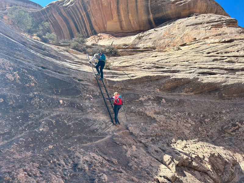
Sipapu Bridge Trailhead
From the visitor center, make a right on Bridge View Drive to get to the Sipapu Bridge Trailhead. Note that this road is one-way, so if you’re planning a car shuttle for this hike, plan accordingly.
From here, the hike down to Sipapu Bridge is a whole lot of fun. There are ladders and stairs to help you get down there safely.
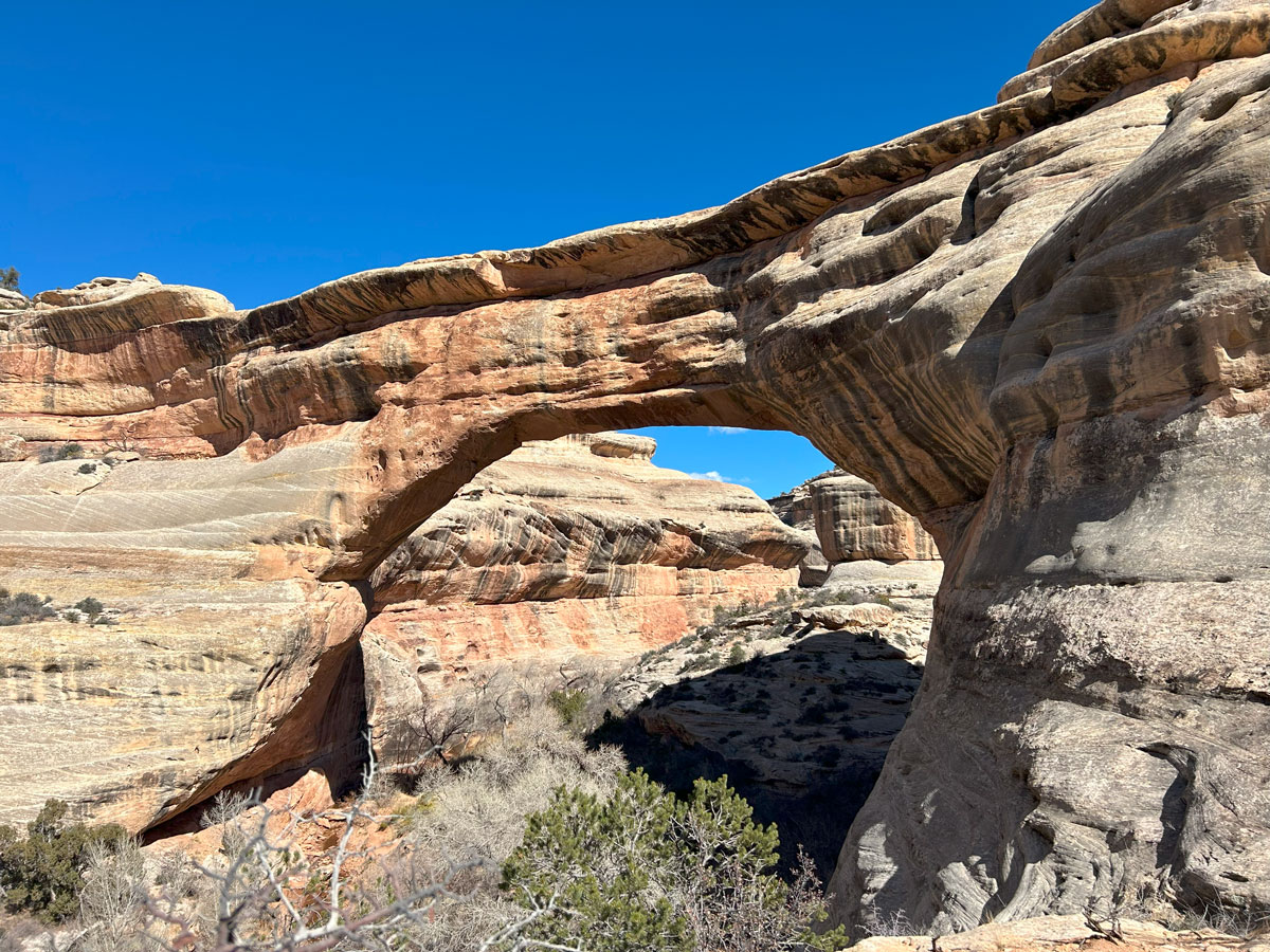
Right away, you’ll get awesome views of the enormous natural bridge.
Continue along the trail until you’re at the bottom of the canyon staring up at it.
Canyon Trail
Once at the bottom of White Canyon, turn left onto Canyon Trail. Although this is an official trail, it feels a heck of a lot like an unofficial trail. Basically, you’ll be trying to find where everyone else as walked and follow it as best you can through the sand, vegetation, and rocks along the stream. We did see some water running initially, but as we progressed along the trail it dried up completely.
Horse Collar Ruins
If you aren’t looking for the Horse Collar Ruins, you’ll likely pass right by them. Ask us how we know. We backtracked about a tenth of a mile after realizing we had passed them, and then we had to do some slightly tricky maneuvers to get up onto the shelf where the ruins are located. But, oh, it was worth it! These were some of the best ruins I’ve ever seen.
At first, we thought it was just a wall, but as we continued along the ledge, we found “The Joneses House” and “The Michaels shopping center.” Okay, we made those names up completely, but they were just so awesome that we almost thought we could be comfortable living there.
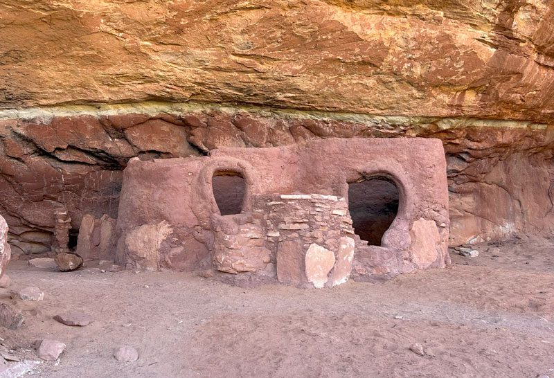
Important note Native American ruins are an important part of our collective American heritage. Please show utmost respect for these sites by not touching, going inside, or climbing on these fragile structures. Help preserve this important piece of history for future generations by not disturbing them in any way. Also, it’s against the law.
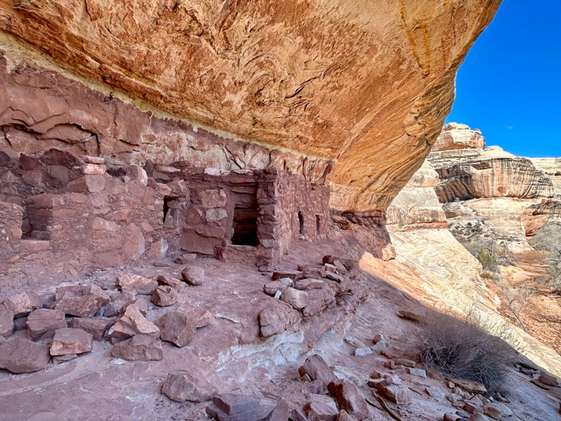
One of the structures even had a wooden roof still intact. So cool!
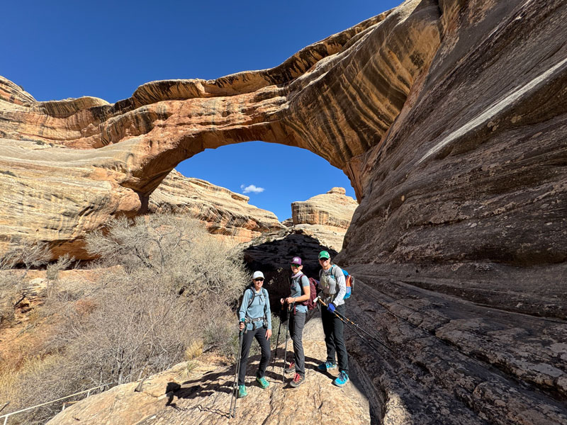
Kachina Bridge
After carefully making your way back to the canyon floor, continue on the Canyon Trail until you reach Kachina Bridge.
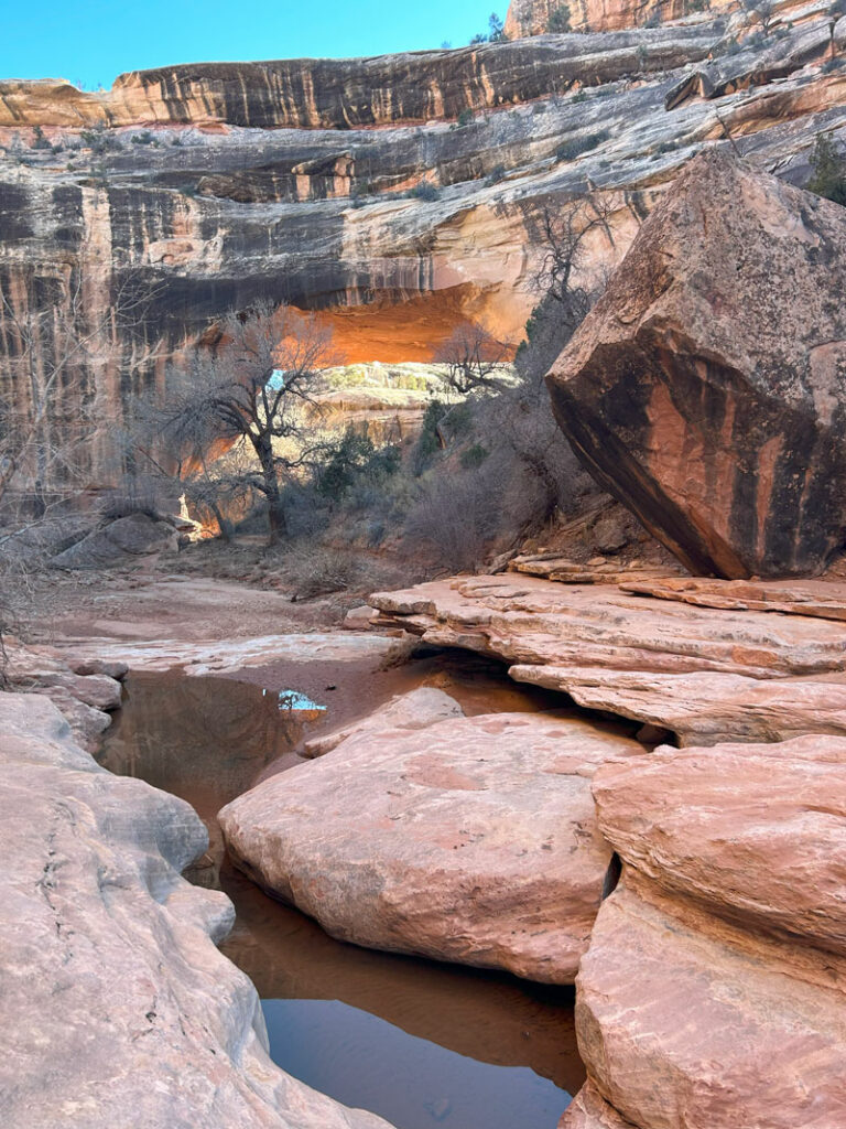
Wowza!
After you pass under Kachina Bridge, watch for the trail to leave the bottom of the canyon. If you miss this turn, you’ll find yourself at a waterfall or dry fall, depending on water flow. Either way, you can’t continue this way. The trail takes you up higher on the left side to bypass the waterfall.
By this time, you’re probably realizing that this hike is taking longer than you planned. Soon you’ll get to a junction where you can either continue on toward Owachomo Bridge or hike out of the canyon. We were low on daylight, so we hiked up to the Kachina Bridge Trailhead and took the trail along the mesa back to our car. This loop was a total of 5.9 miles. Once back at the car, we drove to Owachomo Bridge.
Which means. . . we have no idea what the trail is like between Kachina and Owachomo Bridge. I know, what kind of blog is this? Geez. But my guess is that you’ll encounter the same kind of terrain that you did along the first half of the trail. Don’t quote me on that (and if you know different, please let us know in the comments below).
Owachomo Bridge
Owachomo Bridge is the easiest bridge to access in the monument because it’s not all the way down at the bottom of the canyon. If you hike to it from the parking area at Owachomo Trailhead, it’s only 0.2 miles and 150 feet of elevation gain.
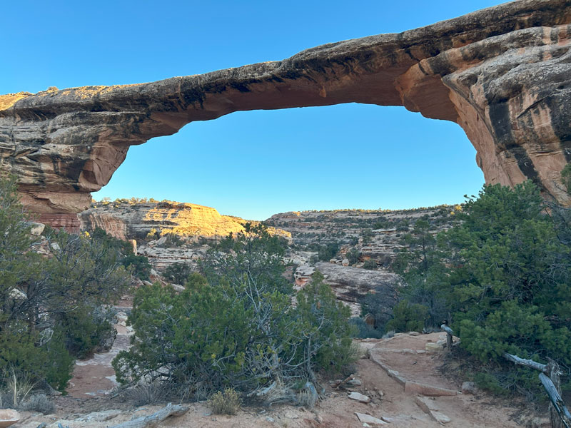
So, if you have limited time or limited physical ability, and you’re yearning to get under one of the bridges, this is the one to do!
Mesa Top Trail
No matter if you hiked all the way to the Owachomo Bridge Trailhead or just to the Kachina Bridge Trailhead, you’ll take the Mesa Top Trail back to your car. This trail is mostly flat and is well-signed, so you shouldn’t have any problem getting back to the Sipapu Bridge Trailhead.
Map & Directions
Location Natural Bridges National Monument, Blanding, Utah
Google Maps Sipapu Trailhead
Fees/Passes There is a fee to enter, or you can use your America the Beautiful pass.
Trailhead Facilities Restrooms available at the visitor center and the Kachina Bridge Trailhead
Preview this Hike
Recommendations for you
Druid Arch with Chesler Park | Canyonlands National Park
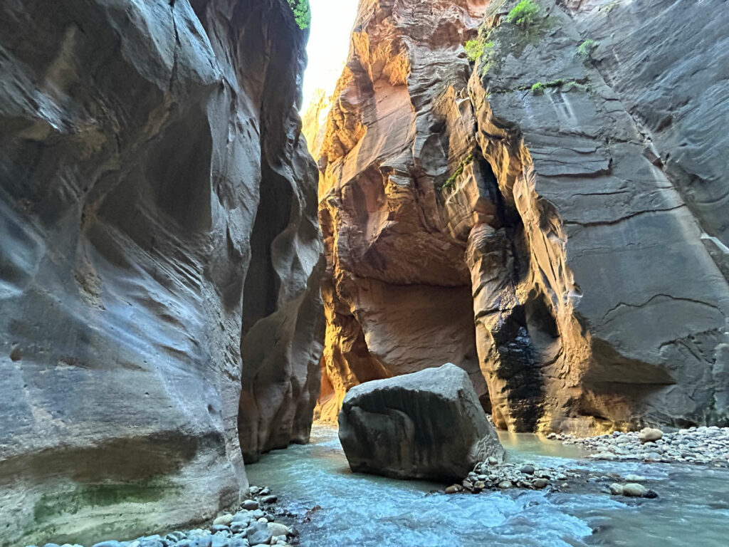
Narrows | Zion National Park
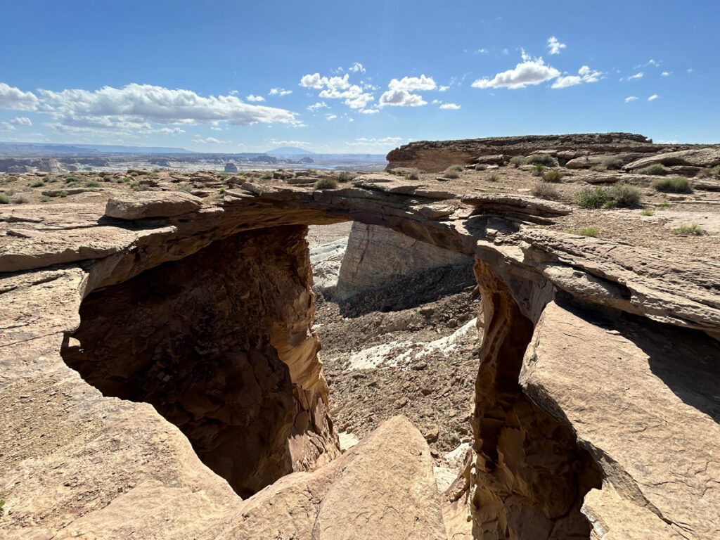
Skylight Arch | Glen Canyon National Recreation Area
Leave a Reply