Paria Canyon
TRAIL STATS
Paria Canyon is one of the most beautiful places in the world. Combined with Buckskin Gulch, it is considered to be the longest slot canyon in the world. This is a canyon that will fill your soul with wonder, and you will miss it as soon as you drive away (well, after you dump your WAG bag).
Trail Description
Only a lucky few get to backpack Paria Canyon. Just 20 spots are given out daily, and for the prime times of the year, they go fast. There were 4 of us on the computer when they opened and only one got in, so dust off those skills you learned trying to get into the Pearl Jam concert, and be logged in and ready right at the stroke of noon (more details about this at the end).
When you enter Paria Canyon from the White House Trailhead, you might start to wonder if there really is something beautiful coming up. Don’t worry, you will be saying “wow” in no time. After walking through a campsite to get down into the wash, we had to jump over some water, but we were able to keep our feet dry until we came to the confluence of Buckskin Gulch and Paria (your results may vary).
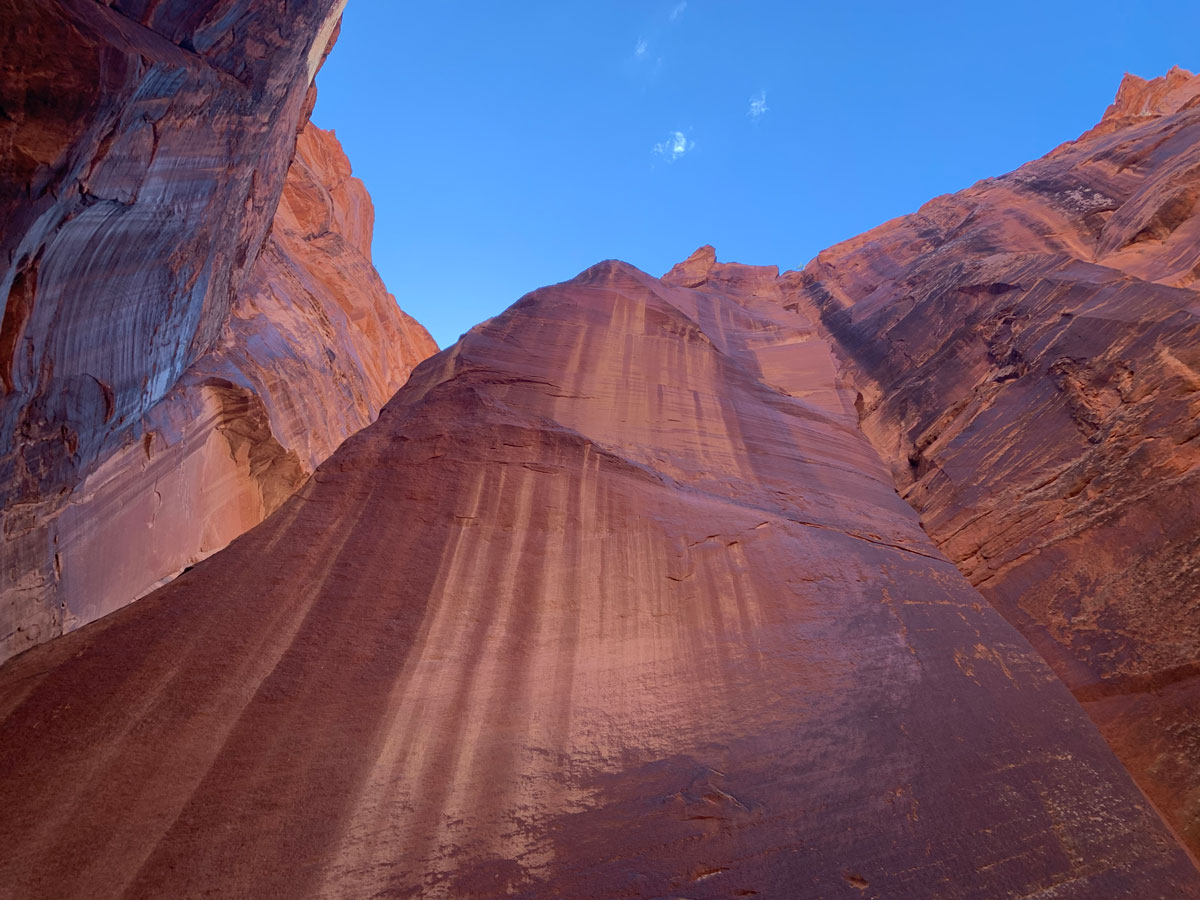
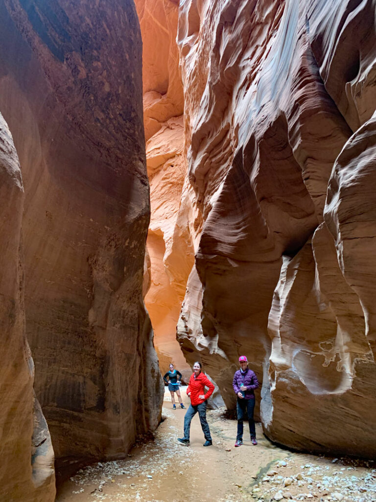
A few miles in, the walls will start speaking to you, and you start to get excited for what you will be seeing the next few days. At the 2.5 mile mark, you will walk under some power lines, and by mile 4, you’ll be in the narrows. The grandeur of this ancient canyon will no doubt begin to envelop your soul and make you feel small—relinquish control and let it happen. You’ll find little alcoves, tunnels, and narrow passages that the water has carved out over time, and the child in you will be awakened and tempted to squeeze into them. Do it!
Slide Rock
Around 6.7 miles you will come to Slide Rock Arch. It is HUGE!
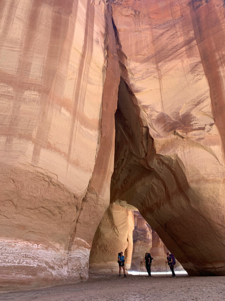
Buckskin Gulch
Soon after Slide Rock Arch is the world famous Buckskin Gulch, a narrow slot canyon tributary to Paria. We only had time to travel 2 miles into Buckskin Gulch, but every inch we could manage was worth it. We had fun climbing the rope up the boulder dam and taking a million pictures as we explored the endless nooks and crannies. Don’t forget to look up!
After Buckskin Gulch, you will be getting your feet wet. Get used to it and enjoy the journey.
There is a campsite at the confluence, but it is overused, so it’s best to keep moving down Paria Canyon to find a camp if you’re through hiking. We hiked a few more miles and found a sweet campsite at mile 9. Because the river was clear, we were able to filter right out of the river, but there is a spring across the river that might be running and can be used when the river is silty. The campsite floor is very fine sand, so walking around in socks is an option. I just wore my neoprene socks as slippers at night because I ended up not wearing them in the water.
Big Spring
The next morning, we packed up and headed toward Big Spring (mile 12). About ¾ mile before you get to it, look off to the left and you will see a side canyon. We ventured into it about ¼ mile and saw some evidence of a campsite where someone had a campfire (a big no no). When we arrived at Big Spring, we realized we had plenty of water and didn’t need to stop, but one of us had it on their bucket list to drink straight from a spring, so we took a nice break and enjoyed the area while everyone took turns drinking from the spring. The water is clear and tastes pretty good, if you like middle school drinking fountains. There’s a large, pretty campsite across from Big Spring if you’re looking for a place to camp.
Wrather Canyon and Arch
At 17.5 miles, you’ll come across Judd Hollow Pump on the left, but you have to look for it or you might miss it. Soon after mile 18, you’ll come to Wrather Canyon entering on the right. The entrance for the canyon is only about 4 feet wide, but it is the only opening in that area, so just keep an eye out for what looks like a water drainage trail. If you find yourself wondering if you’re on the right trail, then you’ve found it. The trail to Wrather Arch is about ½ mile long and all uphill, which is going to feel punishing after being spoiled with a gentle downhill hike to this point, but don’t let that stop you—the arch is worth seeing.
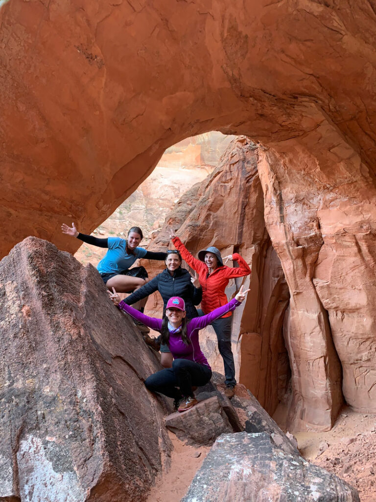
Wrather Canyon is right across from a large campsite we stayed at on our second night. After we all saw the arch, we took turns washing up in the cool river below our campsite. You know there’s no one around, right? Strip yourself down and go for it! It felt so good to be clean—and naked. Just sayin’. To get up to the campsite from the river, you have to push your way through some tall ferns. There is some cactus in this campsite, so be careful where you walk. Those socks you wore last night probably aren’t gonna cut it. Also, you will have some very friendly bats flying around once the sun starts to go down.
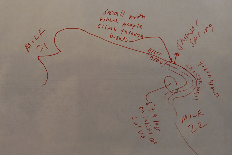
Shower Spring
Shower Spring is at mile 22 on the left, hidden behind some vegetation and across from a large campsite. We did not find this spring, but we were okay with that because we filtered straight from the river. Totally okay, that is, until we found out what we missed out on.
Our friend raved about it and explained how to find it.
On the map, you will see a longer section where the river is fairly straight that heads into Shower Spring. As you approach the far curve that turns to the right, the Shower Spring entrance is on the left just at the beginning of the curve. There is some green growth and weeds growing on the side of the bank. You can see a little spot where people have trampled through the weeds to get up the bank. Go up the bank and you can hear the trickling of water. Follow some marshy ground back up the bank and to the right and end up in a waist-deep pool of perfectly clear, clean water, and you’re surrounded by water trickling off the cliff into the pool.
-Dana Skyles, butt-kickin’ hardcore adventure woman
Sounds pretty idyllic, right? So if you’re on the express train to the next camp, you need to chill yourself out for a minute and take a load off at Shower Spring. And then when you get home, drop us a comment about how dumb we were for not stopping.
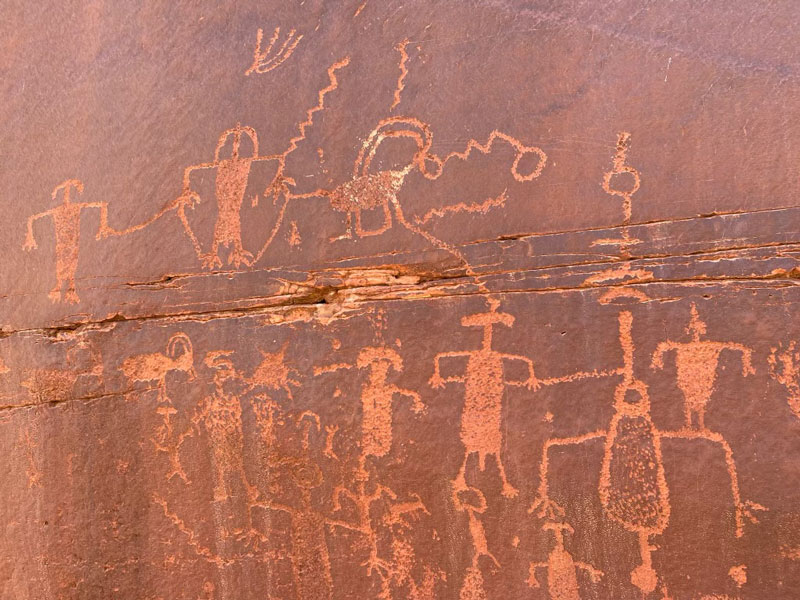
Petroglyphs
Around mile 24.5, before the river takes a sharp left turn, look up at the canyon wall on your left and look for petroglyphs. Drop your packs and follow the tiny little trails up to the red wall. You won’t regret it! About a ½ mile before we came upon the petroglyphs, there was a herd of bighorn sheep on the right side of the river. It was an amazing sight!
Last Reliable Spring
Last Reliable Spring is on the left behind some boulders. I found that a cup under the spring works best because it’s in a tight spot. To help you find the spring, look across the river from a campsite and a large rockslide. Because the Paria River could be silty, some use this spring as their last place to fill up. It is important to be very aware how much water each hiker has because it’s the last reliable spring, and you really can’t claim you didn’t know that, can you? From here on out, the hike is open to the sun, and you are away from the water for a bit if you go the high water route.
High Water Route
Around mile 28, you need to keep an eye on the map and start going up when the trail leads up, if you choose to go to the high water route. We met some people who chose to continue following the river, and they didn’t recommend it, but they wanted to keep their dog cool. Just know it will take you longer to follow the river.
Before we started up and away from the water, we decided to take some time to swim and eat lunch. Great decision! I suggest getting wet if you are hiking in the warmer months. The closer we got to Lee’s Ferry, the hotter it got. Stay cool and hydrated!
There are several options for where to camp on the last night, depending on how short you want your hike to be on the last day. Some of the available options are marked on our map, but there are others. When we arrived at our campsite, we saw the first rodent of our trip, so we packed our WAG bags high in a tree. Nobody wants to wake up to a breached WAG bag. Just don’t forget to take it with you when you leave because the only thing worse than a WAG bag is someone else’s WAG bag.
After setting up camp, we walked down to the river to eat dinner and soak up the sounds and views of our last night in the canyon. Paria Canyon is just amazing! Don’t forget to look up at the stars at night. Stacey said the sky is amazing once the moon goes over the cliffs—she was the only one willing to wake up at 2AM to experience the stars.
Wilson and Lonely Dell Ranches
The last morning we got up at 5AM so we could be out of the canyon before the heat of the day and before the wind picked up (the wind plus sand would have been brutal). There are some ranches, a cemetery, and other historical artifacts to see on your way out.
This is a trip you will always remember. You get to see incredible places that so many others will never get the chance to—and you get to do it with relative solitude in incomparable and unspoiled wilderness.
Paria Canyon Permits
To get a permit you will need to go to Recreation.gov and search for Paria Canyon Overnight Permits. Reservations open at 12 noon (MT) on the 1st of each month for a permit during the third month ahead. For example, for permits for the month of August would become available on May 1st at 12 noon (MT). Note that Arizona is still a cowboy state, and we do things our own way (yee-haw!), so when everybody else is observing daylight savings time, make sure you’re on at 11AM Arizona time/12 noon Mountain Daylight. (We literally have our own time zone.)
Picking Up Your Permit
You must pick up your permit in person no sooner than 10 days before your trip. The most convenient pick up location for this trip is the Paria Contact Station, since it is just a couple miles from the trailhead, but it’s only open March 15 through November 15. If you’re outside the high season, you can get your permit at Vermilion Cliffs National Monument in St. George year-round or the BLM office in Kanab November 16 through March 14.
Map & Directions
Location Paria Canyon Vermilion Cliffs Wilderness Area
White House Trailhead
From Page, travel about 29 miles west on Highway 89 and turn left on White House Trailhead Road. From Kanab, travel about 43 miles east on Highway 89 and turn right on White House Trailhead Road. About a tenth of a mile down, you’ll arrive at the Paria Contact Station, which opens at 8AM Utah time and has water and restrooms (pro tip: do what you can here to minimize your need for WAG bags).
Once you have your permit, drive another mile down the road to the White House Trailhead.
Fees/Passes This hike requires a permit, which you will be required to leave on your dashboard at the White House Trailhead and enter into the trail register. See Paria Canyon Permits above.
Trailhead Facilities Pit toilets, but you used the restroom at the contact station, right?
Lee’s Ferry
You’ll need to drop a shuttle car or arrange for pickup at Lee’s Ferry. The shuttle distance is 75 miles and takes about an hour and a half each way. Near Bitter Springs, AZ, on Highway 89, go north on Highway 89A to Marble Canyon. Take a right on Lee’s Ferry Road/Honeymooon Trail and follow it to the end. There’s a parking lot to the left before the trailhead.
Trailhead Facilities Restrooms and water available.
Preview this Hike
Recommendations for you
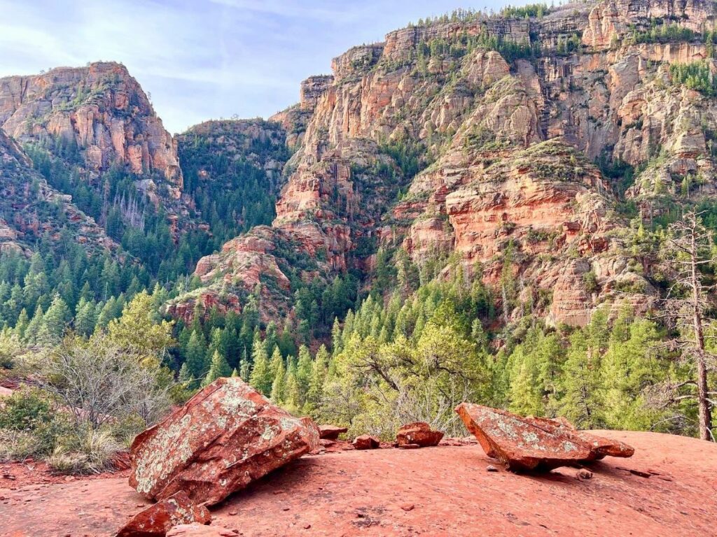
Secret Canyon | Sedona
KP Creek Loop | Blue Range Wilderness
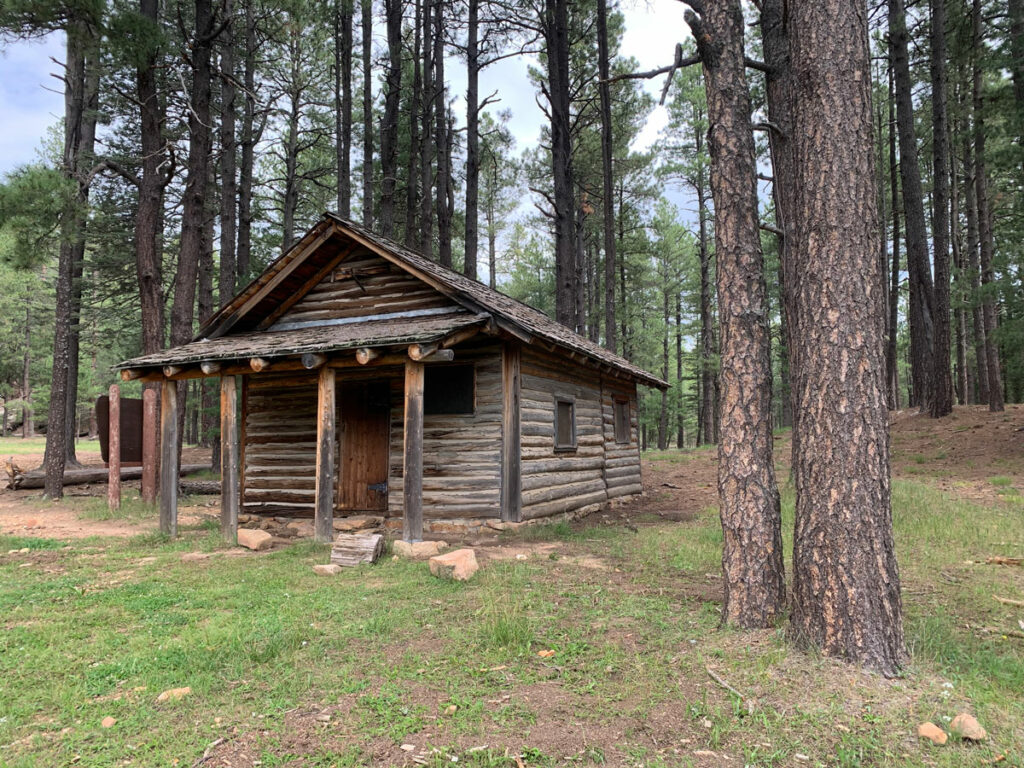
Cabin Loop | Mogollon Rim
Leave a Reply